What is the 3D Mapping and Modeling Market Size?
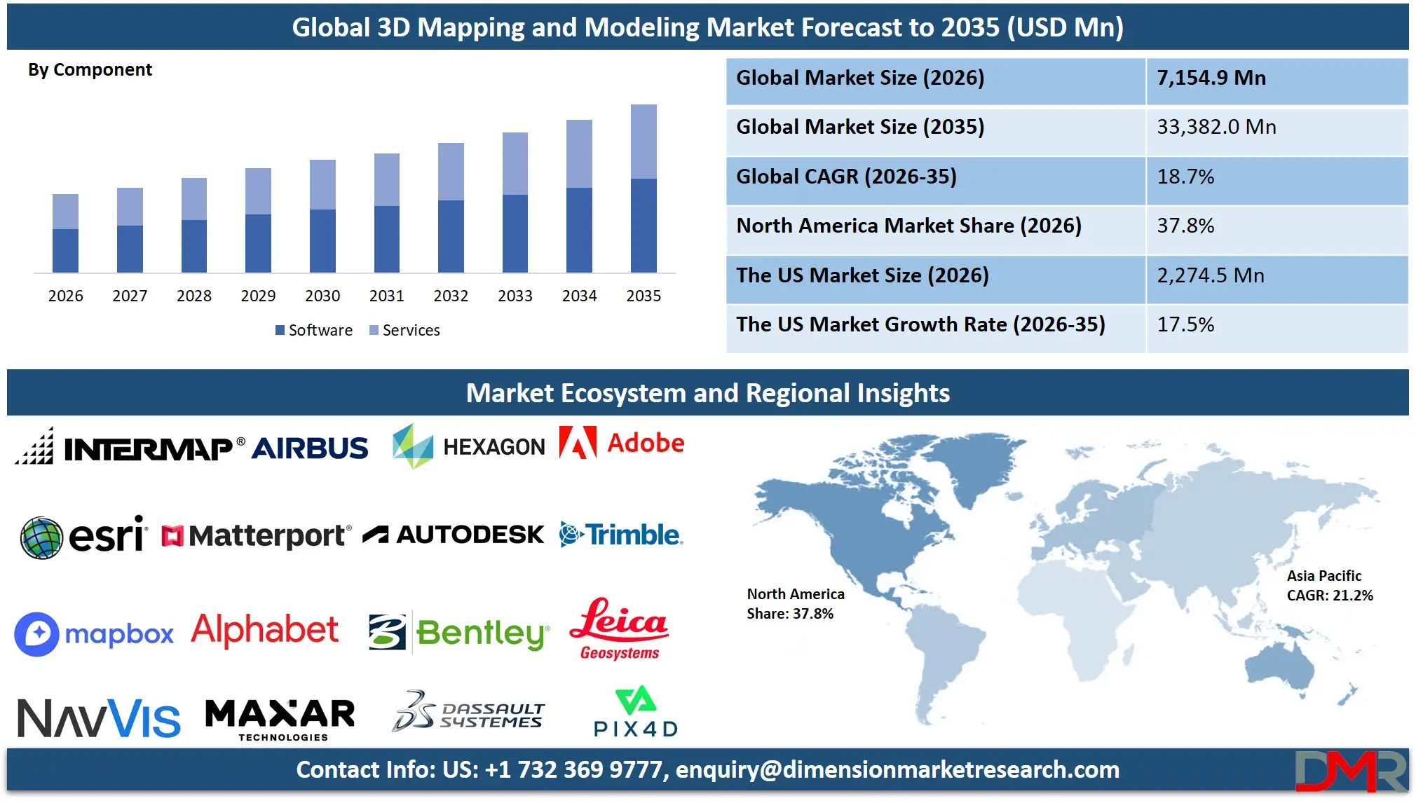
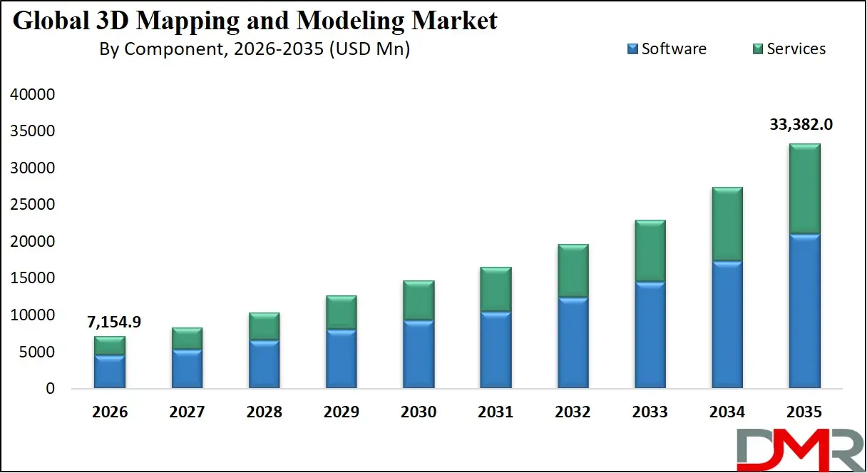
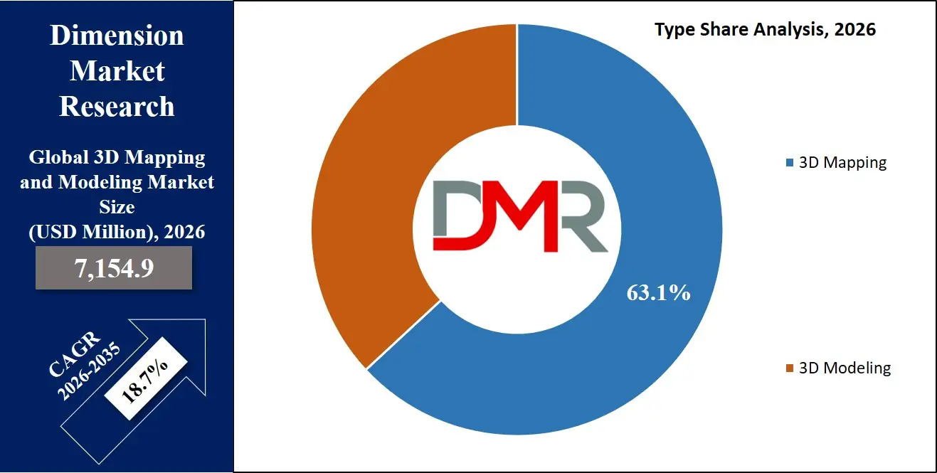
The Global 3D Mapping and Modeling Market is expected to reach a value of USD 7,154.9 million in 2026, and it is further anticipated to reach USD 33,382.0 million by 2035, growing at a CAGR of 18.7% during the forecast period.
ℹ
To learn more about this report –
Download Your Free Sample Report Here
The 3D Mapping & Modeling Market is experiencing exponential growth, as companies globally are accelerating the adoption of digital twin, immersive visualization, and geospatial intelligence technologies. The 3D mapping and modeling business involves data capture, image processing, CAD/BIM modeling, GIS mapping, visualization and analytics, and a broad spectrum of services that include consulting, integration and deployment, maintenance and support, managed services, and training.
The growing need of high-quality spatial information in a variety of fields, including architecture, engineering, construction (AEC), automotive, aerospace, defense, and urban planning, is creating the demand to use more advanced 3D mapping and 3D modeling technology. Enterprises and government bodies are the biggest consumers, and the cloud delivery model has gained tremendous traction due to its scalable nature, collaboration capabilities, and cost-efficiency. The major industrial sectors include AEC, automotive, government, and media and entertainment, because of the necessity to develop a highly accurate and realistic 3D model of the physical environment.
ℹ
To learn more about this report –
Download Your Free Sample Report Here
The US 3D Mapping and Modeling Market
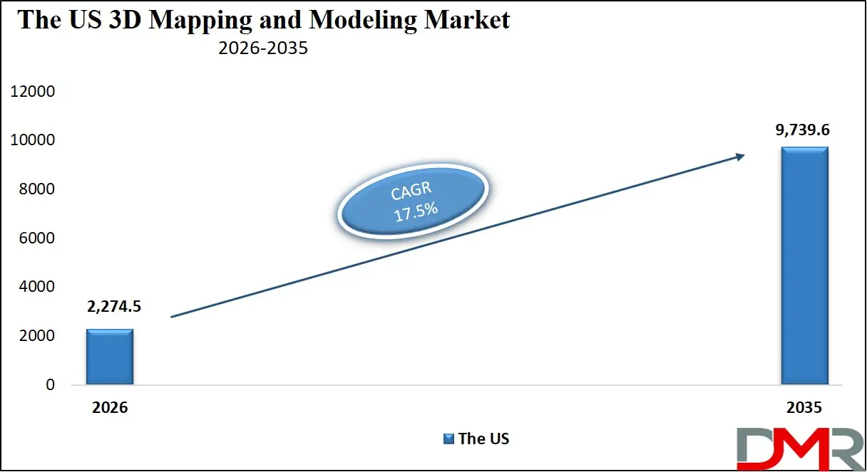
The US 3D Mapping and Modeling Market is projected to reach USD 2,274.5 million in 2026 at a compound annual growth rate of 17.5% over its forecast period, which is further expected to reach a value of USD 9,739.6 million by 2035.
ℹ
To learn more about this report –
Download Your Free Sample Report Here
The US remains the largest and most technologically mature market in 3D mapping and modeling because of the massive federal investments in modernization of infrastructure, defense geospatial intelligence initiatives, and the high rate of development of autonomous vehicles. The skyrocketing demand of CAD/BIM modeling software and GIS mapping software has characterized the market, especially with the increasing pace of smart city projects and transportation infrastructure projects through public-private partnerships across the country. Moreover, the incorporation of artificial intelligence and machine learning solutions into analytics systems is creating concomitant needs in sophisticated consulting and integration services to handle intricate geospatial data processes and to make sure they meet the growing data privacy and security requirements.
The Europe 3D Mapping and Modeling Market
The Europe 3D Mapping and Modeling Market is estimated to be valued at USD 2,075.2 million in 2026 and is further anticipated to reach USD 9,214.5 million by 2035 at a CAGR of 18.0%.
The European market is also characterized by the presence of very strict regulatory frameworks such as the GDPR, the European General Data Protection Regulation, the Energy Performance of Buildings Directive (EPBD), and the European Green Deal, all of which contribute to the growth of the need for accurate building modeling, energy efficiency simulations, and sustainable urban planning solutions. BIM modeling software and GIS mapping software continue to be adopted faster within the region, with countries such as Germany, France, and the Netherlands requiring digital building permits and standardized geospatial data infrastructure. Also, service providers are being pressured by initiatives like the Copernicus Earth observation program and national digital twin strategies to create dedicated integration and deployment services to guarantee data interoperability, security, and compliance across a variety of European mapping ecosystems.
The Japan 3D Mapping and Modeling Market
The Japan 3D Mapping and Modeling Market is projected to be valued at USD 789.4 million in 2026. It is further expected to witness robust growth, holding USD 3,385.6 million in 2035 at a CAGR of 17.6%.
The Japanese market presents distinctive characteristics, driven by a national imperative for advanced disaster resilience mapping, aging infrastructure monitoring, and the digital transformation of the construction sector to address severe labor shortages. Managed services and visualization and rendering software represent a sizable sub-sector of market spending as big construction conglomerates and governmental agencies move to 3D modeling to evaluate seismic risks, simulate floods, and manage infrastructure as a lifecycle. This is accompanied by a strong demand of localized integration and training services to close the divide between the traditional surveying methodologies and the high-tech photogrammetry, LiDAR, and SLAM technologies, to open specialized opportunities in consulting, and support, and maintenance segments.
Key Takeaways
- Market Size & Forecast: The Global 3D Mapping and Modeling market is estimated to grow to USD 7,154.9 million in 2026 and reach USD 33,382.0 million in 2035 due to the integration of digital twins, the emergence of autonomous systems, and the global adoption of mandatory infrastructure digitalization requirements.
- Growth Rate & Outlook: Global market growth is expected at a CAGR of 18.7%, driven by critical shortages of skilled geospatial professionals, the escalating complexity of managing multi-source 3D data pipelines, and the growing imperative for real-time visualization in mission-critical applications.
- Primary Growth Drivers: Widespread migration of traditional 2D CAD workflows to intelligent 3D BIM processes, the necessity of specialized consulting to make complex hardware and software purchases, and integration of AI-powered analytics platforms that demand advanced data capture and image processing solutions are major drivers.
- Key Market Trends: Key trends pushing the growth of this market are the emergence of industry-focused 3D modelling solutions in areas such as healthcare and manufacturing, the application of generative AI technology in visualization and rendering software to speed up the creation of content.
- By Component Analysis: Software solutions are poised to dominate due to repeated subscriptions, premium CAD/BIM and GIS platforms, and rising demand for image processing and data capture tools generate higher revenue than consulting, deployment, and training services.
- By Deployment Mode Analysis: The cloud-based deployment models is projected to dominate this segment as they are likely to receive a massive push because of their natural scalability and accessibility benefits. To ensure on-premises data capture systems are safely combined with cloud-hosted processing and visualization services, professional services are more in demand.
- By End-Use Industry Analysis: Architecture, Engineering and Construction (AEC) is expected to dominate this segment as the largest verticals in this market due to the high regulatory compliance requirements to infrastructure projects and public safety applications.
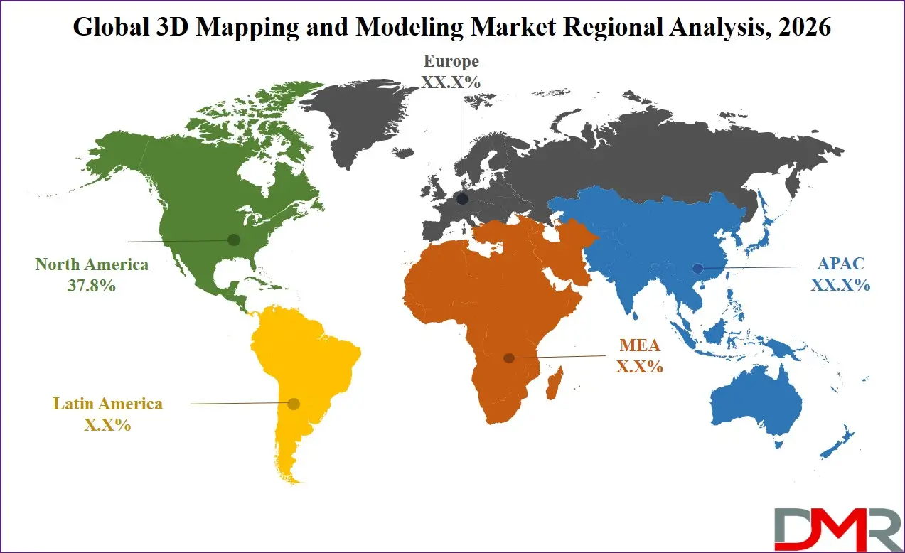
- Regional Leadership: North America is poised to dominate this market with 37.8% of the market share in 2026 due to its mature technology ecosystem, substantial venture capital investment in geospatial startups, and comprehensive federal mapping programs that drive continuous innovation and adoption.
What is the 3D Mapping and Modeling Market?
The terminology of 3D Mapping and Modeling refers to the professional software, hardware, and service provider ecology of generating, analyzing, and displaying 3Dm models of physical objects, physical environments, and physical terrain. When compared to the conventional 2D documentation techniques, 3D mapping and modeling offers a spatial context, volumetric accuracy and immersive visualization features that are so vital in the contemporary design, simulation, and decision-making processes. Software solutions found in the market include data capture software to acquire raw spatial data, image processing software to turn imagery into usable 3D geometry, CAD/BIM modeling software to design and document in detail, GIS mapping software to analyze geospatial data, visualization and rendering software to create photorealistic presentations, and analytics platforms to extract actionable insights about 3D data.
The complementary services are strategy technology adoption consultancy, integration and deployment consultancy which ensures a smooth implementation of workflow, support and maintenance consultancy which ensures continuous operational reliability, managed services which outsources 3D data processing to third parties, and training services which develops organizational competency. As more than three-quarters of large-scale infrastructure projects now require BIM deliverables and more sensors are being developed that can record 3D data, professional services are needed to verify the accuracy of data, efficiency of workflow, and payback in this technically challenging sphere.
Use Cases
- Digital Twin Creation for Infrastructure Assets: Government transportation agencies and other infrastructure operators use LiDAR, photogrammetry, and SLAM technologies with CAD/BIM modeling software to develop complete digital twins of tunnels, bridges, and highways.
- Autonomous Vehicle High-Definition Mapping: Mobile LiDAR systems, imaging sensors, and specialized GIS mapping software are utilized by autonomous vehicle manufacturers and technology firms to create high-definition 3D maps that autonomous vehicles rely on to navigate.
- Cultural Heritage Preservation and Virtual Tourism: Museums, archaeological institutions, and tourism authorities employ structured light scanning, photogrammetry, and visualization & rendering software to create precise 3D models of historical artifacts, monuments, and heritage sites.
- Construction Progress Monitoring and Quality Control: Construction companies are using drones with photogrammetry and ground laser scanners combined with analytics to conduct routine 3D scans of construction sites underway.
How AI is Transforming the 3D Mapping and Modeling Market?
AI is changing the field of 3D mapping and modeling fundamentally by automating processes that are labor-intensive and improving analytical capabilities. In data capture software and image processing software, AI-powered algorithms may automatically label point cloud data, detect and isolate certain features like building footprints, road edges, and vegetation of raw LiDAR and photogrammetry data, greatly reducing the time and human error of manual processing. At the same time, AI-powered analytics tools can be used to perform automated object identification, detect differences between time-stamped data, and perform predictive analytics of depreciation patterns among assets, allowing organizations to leave reactive documentation behind and move towards proactive asset management.
The AI is also revolutionising governance and quality assurance workflows. In managed services and consulting services projects, smart algorithms constantly compare the accuracy of 3D models with source data, identify possible registration errors, data missing, and geometry inconsistencies, and prevent their spread to downstream processes.
Market Dynamics
Key Drivers in the Global 3D Mapping and Modeling Market
The Global Geospatial Skills Shortage
Global organizations are struggling greatly with the employment and retention of professionals possessing knowledge of the latest 3D mapping methodologies, such as LiDAR processing, photogrammetry, BIM management, and geospatial data science. The supply of these specialized skills significantly lags behind the output of academic and vocational training programs, and this presents a structural talent deficit in industries. This discontinuity has forced businesses and government departments to outsource to external consulting, integration and deployment, and managed services firms instead of focusing on development of the in-house capability. By sourcing these functions, organizations can speed up their project schedules, on-demand expert knowledge, and reduce the risks linked to the curves of technology adoption.
Complexity of Multi-Sensor Data Fusion
The latest 3D mapping processes are heavily based on the integration of data of heterogeneous sensor systems such as terrestrial laser scanners, aerial LiDAR systems, drone-based cameras, mobile mapping vehicles, and satellite imaging. Substantial technical challenges are involved in managing, calibrating, and integrating these varying streams of data into consistent 3D models. Companies need to coordinate different coordinate reference frames, balance different resolution and accuracy requirements, and deal with huge amounts of data produced by high-frequency sensors. This complexity requires dedicated image processing software, data capture software integration skills and continuous support and maintenance consulting services to ensure continuity in its operation.
Restraints in the Global 3D Mapping and Modeling Market
High Initial Capital Investment Requirements
The purchase of professional-grade 3D mapping equipment, such as high-quality LiDAR sensors, laser scanners, and specialist imaging equipment, is a huge capital investment barrier to most organizations, especially small and medium enterprises. As well, the licenses of the software required to run the more advanced CAD/BIM modeling software and GIS mapping software are usually either subscription or perpetual licensing with high per-year fees. This economic impediment often postpones or defers the 3D mapping technology adoption, especially in the low-cost industries and in developing economies.
Data Interoperability and Format Fragmentation
A landscape of proprietary and open file formats, tailored to workflow and software environment, remains a part of the 3D mapping and modeling ecosystem. LiDAR generated data can often need to be converted prior to ingestion into CAD/BIM modeling software, and photogrammetry generated data may not be easily ingested into GIS mapping software without further processing measures. This fragmentation of formats creates a huge workflow burden, higher error rates in data translation, and requires special integration and deployment services to build functional data pipelines.
Growth Opportunities in the Global 3D Mapping and Modeling Market
Digital Twin Integration for Smart City Infrastructure
There is also a large potential growth in supporting municipalities and urban planning agencies to come up with complex city-scale digital twins that combine 3D mapping information with real-time sensor networks and operational systems. Such advanced platforms need professional consulting services to establish data governance models, integration and deployment services to interlink divergent municipal systems, and long-term managed services to keep 3D models up to date and accurate. Professional service providers with the ability to offer end-to-end smart city 3D mapping solutions, including data capture, modeling, analytics and visualization, will be able to reap substantial value as urban populations and complexity of the infrastructure continue to grow.
Industrial Metaverse and Immersive Training Solutions
The industrial metaverse application is creating a demand in high-fidelity 3D content of manufacturing plants, energy plants, and logistics centers. Companies are interested in using these 3D resources as the basis of immersive training simulators, distance work, and planning operation scenarios. This pattern opens up prospects of specialised object modeling and infrastructure modeling services, coupled with knowledge of visualization and rendering software to produce photorealistic interactivity. This area is critical, especially with the training services, where organizations must have workforce development initiatives in order to be able to use the immersive 3D platforms, to be able to utilize them in operational and safety training applications.
Trends in the Global 3D Mapping and Modeling Market
The Rise of Reality Capture-as-a-Service
Companies are moving towards outsourced reality capture models whereby professional service vendors utilize advanced LiDAR, photogrammetry, and SLAM technology to scan 3D data on a project or recurring schedule. This managed services model allows organizations to get state-of-the-art capture technology without capital investment and enjoy the services of professional capture experts who provide assurance of quality and completeness of data. The service providers are building their own analytics platforms and workflow automation platforms to distinguish their service offerings beyond simple data collection.
Sustainability Analytics Integration
The concept of environmental sustainability is becoming a key consideration in 3D mapping and modeling projects as organizations are pressured to fulfill ESG reporting mandates and carbon reduction goals. Solar potential analysis, energy efficiency simulation, and urban heat island analysis are also being done using 3D building modeling and GIS mapping software. Professional service providers are working on specialized consulting practices in which they integrate expertise in 3D mapping with knowledge in the sustainability domain; this allows their clients to measure and maximize the environmental performance of the proposed and existing built assets.
Research Scope and Analysis
The research scope highlights strong growth driven by software-led ecosystems, cloud adoption, and LiDAR technology, with AEC dominance, rising SME participation, and expanding applications in urban planning, navigation, and infrastructure development.
ℹ
To learn more about this report –
Download Your Free Sample Report Here
By Component Analysis
The software solutions are poised to dominate this market as it holds the largest share of the revenue in the component segment of the global 3D mapping and modeling industry due to recurring licensing and subscription models that define software ecosystems of the recent geospatial and design software industries. In the software market, CAD/BIM modeling software and GIS mapping software are highly important source of revenue as they are considered to be mission-critical in the AEC, government and infrastructure planning processes. These software platforms are priced at a premium based on their advanced features and crucial contribution to regulatory compliance and project delivery. Image processing software/data capture software are witnessing faster growth as organizations automate the conversion of the raw sensor data into actionable 3D intelligence. In the meantime, the services business is set to experience strong growth as organizations turn to the specialized knowledge of consulting, integration, and deployment services, and training services to leverage software investments and overcome complicated technology procurement and implementation choices.
By Type Analysis
The 3D mapping is expected to lead this market with the largest market share in type segment, which is the essential requirement of the correct spatial data acquisition in various environments. Outdoor mapping applications take up almost all of the 3D mapping category because of the wide range of applications in urban planning, infrastructure development, autonomous vehicle navigation, and environmental monitoring. The 3D modeling industry, which includes object modeling, building modeling, character modeling, infrastructure modeling, and reverse engineering models, is under a rapid growth due to the adoption of digital twins, digitizing product design and the spread of immersive media applications. The construction of modeling, especially modeling, is gaining momentum as the BIM requirements are being implemented in the world construction industries both in the government and the private sectors.
By Deployment Mode Analysis
Cloud-based deployment models is expected to lead this segment as they are experiencing considerable push in the market because of the benefits they offer in terms of fostering cooperation between geographically dispersed project team members, providing access to scalable computational resources to process and render intensive image processing and rendering loads, and lowering IT infrastructure management burdens. Companies are moving toward cloud-based CAD/BIM modeling software and GIS mapping software that support sharing of models in real-time, version control and built-in commenting processes. Nevertheless, on-premises deployment is still applicable in defense, intelligence, and critical infrastructure applications where data sovereignty, security classification needs, and air-gapped operations environments require local hosting of sensitive 3D mapping data and modeling software.
By Organization Size Analysis
Large enterprises are expected to represent the largest market segment based on organization size, as they have large capital budgets to purchase technology, complex project portfolios that demand advanced 3D mapping abilities, and internal dedicated teams to operate geospatial and BIM programs. Such organizations generally have multi-year enterprise deals with significant software vendors and outsource consulting and integration and deployment services with specific project needs. SMEs are a relatively large and increasingly significant market segment with the barriers to entry to cloud-based deployment models, subscription software licensing, and managed services evolving. AEC, manufacturing and media SMEs are utilizing the available 3D mapping and modeling solutions to improve competitiveness and differentiation of services offered.
By Technology Analysis
LiDAR technology is expected to maintain a leading position within the technology segment due to its high accuracy, high density point cloud production, and its ability to operate on aerial, land, and mobile mapping systems. The capability of the technology to reach the vegetation canopy and record bare earth topography makes it a key to the mapping of the terrain, inspection of infrastructure, and forestry. Photogrammetry is increasingly becoming popular due to the spread of high-resolution drone and smartphone cameras, democratizing access to 3D reconstruction features, among a wide range of users. Indoor mapping applications where GPS signals are not available are seeing a rapid adoption of SLAM technology and it allows efficient mapping of building interiors, industrial facilities and underground infrastructure.
By Application Analysis
Inspection and measurement applications are one of the key elements of the 3D mapping and modeling market, which facilitates non-contact dimensional analysis, deformation, and quality control in industries of manufacturing, construction, and infrastructure. Maps and navigation apps are growing fast with autonomous vehicle development, deployments of indoor positioning systems, and augmented reality navigation experiences. One of the rapidly growing areas of application is urban planning and smart cities where municipalities around the world utilize 3D mapping and modeling to make zoning decisions, prioritize infrastructure investments, and climate adaptation planning. Applications of projection mapping and texture mapping are niche markets of high value but with a very limited market share in media and entertainment, experiential marketing, and cultural heritage interpretation.
By End-Use Industry Analysis
The Architecture, Engineering and Construction (AEC) will is poised to continue to be the largest sector of end-use industry spurred by extensive use of BIM, regulatory requirements that digital project delivery is mandatory and the productivity pressures of meeting infrastructure shortages around the world. The end-to-end process of the AEC industry, encompassing conceptual design and construction and facilities management, generates long-term demand throughout the entire range of 3D mapping and modeling software and services. Another significant vertical is government, where national mapping agencies, defense services, and municipal governments invest in geospatial intelligence, urban planning, and applications in the field of public safety. The fastest-growing end-use segment is automotive and transportation, which is being driven by autonomous mapping of vehicles, digitization of transportation infrastructure and overall mobility transformation.
The Global 3D Mapping and Modeling Market Report is segmented on the basis of the following:
By Component
- Software
- Data Capture Software
- Image Processing Software
- CAD / BIM Modeling Software
- GIS Mapping Software
- Visualization & Rendering Software
- Analytics Platforms
- Services
- Consulting
- Integration & Deployment
- Support & Maintenance
- Managed Services
- Training Services
By Type
- 3D Mapping
- Indoor Mapping
- Outdoor Mapping
- Terrain Mapping
- Underground Mapping
- Marine Mapping
- 3D Modeling
- Object Modeling
- Building Modeling
- Character Modeling
- Infrastructure Modeling
- Reverse Engineering Models
By Deployment Mode
By Organization Size
- Large Enterprises
- Small & Medium Enterprises (SMEs)
By Technology
- LiDAR
- Photogrammetry
- Structured Light Scanning
- SLAM (Simultaneous Localization and Mapping)
- Laser Scanners
- Imaging Sensors
- Radar
- Sonar
- Others
By Application
- Projection Mapping
- Texture Mapping
- Maps & Navigation
- Inspection & Measurement
- Object Reconstruction
- Product Design
- Reporting & Virtualization
- Urban Planning & Smart Cities
- Others
By End-Use Industry
- Architecture, Engineering & Construction (AEC)
- Automotive & Transportation
- Aerospace & Defense
- Healthcare & Life Sciences
- Media & Entertainment
- Manufacturing
- Logistics
- Government
- Agriculture
- Energy & Utilities
- Education
- Others
Regional Analysis
Leading Region by Market Share
North America is poised to dominate the global 3D mapping and modeling market, as it is projected to hold 37.8% of the market share by the end of 2026. Being one of the primary drivers of the regional market, the US derives strength from a unique cluster of technology pioneers, large investments made in geospatial programs such as 3D Elevation Program (3DEP), and aggressive adoption of digital transformation. The presence of a highly developed ecosystem that consists of software developers, hardware suppliers, specialized service providers, and research centers, along with consistent innovation in technologies such as LiDAR, photogrammetry, and BIM, adds to the attractiveness of the market here. High-level demand for enterprise digital twin initiatives, and requirements for high-resolution 3D geospatial datasets by defense and intelligence organizations, further add impetus to demand across software and services segments. In addition, venture capital funding for analytics platforms, AI image processing software, and other advanced applications is quite prevalent in the region.
ℹ
To learn more about this report –
Download Your Free Sample Report Here
Fastest-Growing Regional Market
The Asia-Pacific region is projected to become the fastest growing regional market for 3D mapping and modeling due to its unparalleled activity in infrastructure projects, its push towards creating smart cities, as well as the implementation of national geospatial programs by such countries as China, India, Japan, South Korea, and Southeast Asian nations. Urbanization processes, expansion of transport systems, as well as government policies requiring the implementation of digital techniques in construction have forced both public bodies and businesses to implement 3D mapping and modeling solutions. The most popular services include consulting services and integration & deployment services aimed at helping organizations navigate through selecting the appropriate software, developing workflows, and building capabilities for its effective usage. In addition to that, there is a shortage of skilled professionals in this region, which makes the involvement of managed services and training services absolutely necessary to promote faster adoption of technologies and ensure successful implementation of projects.
By Region
North America
Europe
- Germany
- The U.K.
- France
- Italy
- Russia
- Spain
- Benelux
- Nordic
- Rest of Europe
Asia-Pacific
- China
- Japan
- South Korea
- India
- ANZ
- ASEAN
- Rest of Asia-Pacific
Latin America
- Brazil
- Mexico
- Argentina
- Colombia
- Rest of Latin America
Middle East & Africa
- Saudi Arabia
- UAE
- South Africa
- Israel
- Egypt
- Rest of MEA
Competitive Landscape
The global 3D mapping and modeling market has a competitive environment that is marked by a developed ecosystem of established enterprise software vendors, specialized geospatial technology vendors, hardware vendors with integrated software platforms, and start-up ventures with niche applications. Technology alliances and strategic partnerships are essential competitive differentiators that allow providing end-to-end solutions in data capture, processing, modeling, analytics, and visualization. The consolidation of the market is gaining momentum with the acquisition of specialized software developers and service providers by larger technology companies to widen solution portfolios and meet changing customer needs. The intellectual property assets that enable competition positioning include proprietary algorithms of automated feature extraction, point cloud classification, and 3D reconstruction. Market leadership is increasingly being determined by the capability to provide end-to-end workflows that are integrated and bridge seamlessly the field data capture with the enterprise design and asset management systems.
Some of the prominent players in the Global 3D Mapping and Modeling Market are:
- Autodesk, Inc.
- Esri
- Trimble Inc.
- Bentley Systems, Incorporated
- Hexagon AB
- Leica Geosystems
- Topcon Corporation
- Dassault Systèmes SE
- Adobe Inc.
- Alphabet Inc. (Google)
- Airbus SE
- Matterport, Inc.
- Pix4D SA
- Maxar Technologies
- Mapbox, Inc.
- Intermap Technologies Corp.
- FARO Technologies, Inc.
- NavVis GmbH
- Blue Marble Geographics
- CyberCity 3D, Inc
- Other Key Players
Recent Developments
- February 2026: Autodesk expanded its capabilities of artificial intelligence in BIM 360 software by adding features such as clash detection and generative design, utilizing AI algorithms to optimize layout of building systems and making life easier for architectural, engineering, and construction professionals involved in modeling of infrastructures and buildings.
- December 2025: Reality capture specialist Hexagon AB added a new member to its suite of products through the acquisition of a company developing specialized software for automated feature extraction from lidar and photogrammetry datasets, improving the capabilities of its data capture and image processing software solutions.
- September 2025: Trimble Inc. unveiled a complete cloud-based collaboration tool combining its geographic information system software solution with CAD/BIM modeling tools and analytics platform, facilitating data exchange between project members involved in transportation and urban development projects.
Report Details
| Report Characteristics |
| Market Size (2026) |
USD 7,154.9 Mn |
| Forecast Value (2035) |
USD 33,382.0 Mn |
| CAGR (2026–2035) |
18.7% |
| The US Market Size (2026) |
USD 2,274.5 Mn |
| Historical Data |
2021 – 2025 |
| Forecast Data |
2027 – 2035 |
| Base Year |
2025 |
| Estimate Year |
2026 |
| Segments Covered |
By Component (Software, and Services), By Type (3D Mapping, and 3D Modeling), By Deployment Mode (Cloud-Based, and On-Premises), By Organization Size (Large Enterprises, and Small & Medium Enterprises (SMEs)), By Technology (LiDAR, Photogrammetry, Structured Light Scanning, SLAM (Simultaneous Localization and Mapping), Laser Scanners, Imaging Sensors, Radar, Sonar, and Others), By Application (Projection Mapping, Texture Mapping, Maps & Navigation, Inspection & Measurement, Object Reconstruction, Product Design, Reporting & Virtualization, Urban Planning & Smart Cities, and Others), By End-Use Industry (Architecture, Engineering & Construction (AEC), Automotive & Transportation, Aerospace & Defense, Healthcare & Life Sciences, Media & Entertainment, Manufacturing, Logistics, Government, Agriculture, Energy & Utilities, Education, and Others) |
| Regional Coverage |
North America – The US and Canada; Europe – Germany, The UK, France, Russia, Spain, Italy, Benelux, Nordic, & Rest of Europe; Asia-Pacific – China, Japan, South Korea, India, ANZ, ASEAN, Rest of APAC; Latin America – Brazil, Mexico, Argentina, Colombia, Rest of Latin America; Middle East & Africa – Saudi Arabia, UAE, South Africa, Turkey, Egypt, Israel, & Rest of MEA |
Frequently Asked Questions
How big is the Global 3D Mapping and Modeling Market?
▾ The Global 3D Mapping and Modeling market is poised to be valued at USD 7,154.9 million in 2026 and is projected to reach USD 33,382.0 million by 2035, driven by the universal need for accurate spatial intelligence, digital twin adoption, and immersive 3D visualization capabilities across diverse industries.
What is the CAGR of the Global 3D Mapping and Modeling Market from 2026 to 2035?
▾ The market is expected to grow at a CAGR of 18.7% from 2026 to 2035, reflecting the accelerating complexity of 3D data capture and processing workflows and the persistent shortage of internal geospatial and BIM expertise within organizations.
What factors are driving the growth of the Global 3D Mapping and Modeling Market?
▾ Key drivers include the global shortage of skilled geospatial professionals, the imperative to modernize infrastructure asset management practices, the management complexity of multi-source 3D data integration, and surging demand for digital twins and smart city solutions amid evolving sustainability and regulatory requirements.
Which region held the largest share of the 3D Mapping and Modeling Market in 2026?
▾ North America is expected to dominate this market as it holds 37.8% of market share in 2026, driven by a mature technology ecosystem, substantial federal mapping programs, and aggressive enterprise investment in CAD/BIM modeling software, GIS mapping software, and AI-driven analytics platforms.
Which region is expected to grow the fastest in the 3D Mapping and Modeling Market?
▾ The Asia-Pacific region is expected to grow the fastest, fueled by rapid infrastructure development, comprehensive smart city initiatives, and government-led digital transformation programs in China, India, Japan, and Southeast Asia, where consulting and integration & deployment services are critical for successful technology adoption.
What are the major trends in the Global 3D Mapping and Modeling Market?
▾ Major trends include the integration of generative AI into visualization and rendering software, the rise of reality capture-as-a-service and managed services models, the demand for industry-specific 3D modeling solutions, and increasing focus on sustainability analytics integration within building modeling and urban planning applications.
Who are the key players in the Global 3D Mapping and Modeling Market?
▾ Key players include established enterprise software vendors like Autodesk, Bentley Systems, Trimble, Hexagon, Esri, and Dassault Systèmes, as well as specialized hardware and software providers including FARO Technologies, Leica Geosystems, Matterport, and emerging AI-focused geospatial analytics companies.
How is the Global 3D Mapping and Modeling Market segmented?
▾ The market is segmented by Component, Type, Deployment Mode, Organization Size, Technology, Application, and End-Use Industry.