What is the Japan LiDAR Market Size?
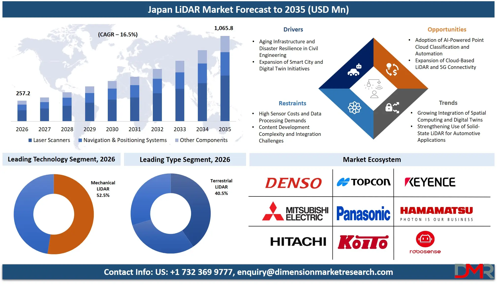
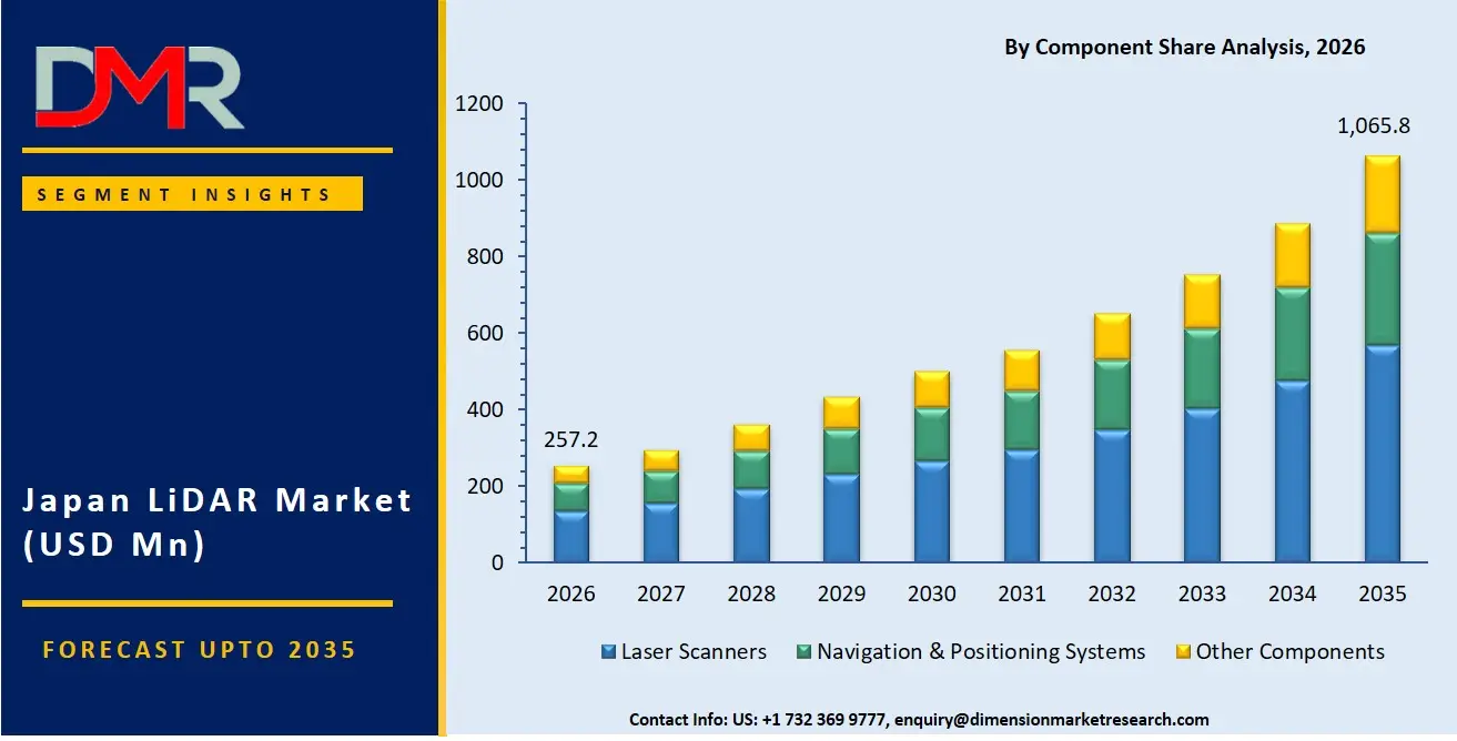
The Japan LiDAR Market is expected to reach a value of USD 257.2 million in 2026, and it is further anticipated to reach USD 1,065.8 million by 2035, growing at a CAGR of 16.5% during the forecast period.
ℹ
To learn more about this report –
Download Your Free Sample Report Here
The LiDAR market has been showing consistent growth due to Japan's rising dependence on high-precision 3D sensing solutions that capture detailed spatial data for real-time mapping, infrastructure monitoring, and autonomous navigation. This includes several hardware components, software platforms, and professional services that help government and enterprise users deploy LiDAR for residential, commercial, and industrial purposes.
There has been a rising need for custom LiDAR development owing to the requirements for implementing advanced point cloud algorithms, securing operational continuity in disaster-prone regions, and delivering high-performance 3D visualization systems to customers. Large enterprises have emerged as the largest end-user segment for LiDAR services, with mobile & UAV LiDAR being the most popular type due to their flexibility and rapid data acquisition, while there has been rapid growth in solid-state LiDAR technologies and cloud-based analytics services.
ℹ
To learn more about this report –
Download Your Free Sample Report Here
Key Takeaways
- Market Size & Forecast: The Japan LiDAR market is forecasted to be valued at USD 257.2 million in 2026, growing incrementally to USD 1,065.8 million by 2035, due to the joint efforts of digital transformation deployment on the part of enterprises as well as the mandatory adoption of high-definition mapping and AI-powered point cloud visualization technologies.
- Growth Rate & Outlook: Japan market is expected to grow at 16.5% CAGR, propelled by the urgent need to mitigate emerging infrastructure aging vulnerabilities in bridge and tunnel maintenance, alongside increasing challenges in monitoring coastal changes and forest density across Japan's mountainous terrain, earthquake-prone zones, and extensive coastline.
- Primary Growth Drivers: Major driving factors comprise the transition from traditional surveying methods toward modern 3D LiDAR systems, the necessity to deploy remote sensing for disaster risk assessment and infrastructure inspection, as well as the adoption of AI-powered point cloud classification and real-time object recognition for ADAS and autonomous driving applications.
- Key Market Trends: Major trends encompass the introduction of AI-driven point cloud semantic segmentation through 5G networks, usage of simultaneous localization and mapping (SLAM) within indoor environments for asset tracking and facility management, and increased focus on lightweight, solid-state LiDAR sensors amidst rising automotive safety considerations.
- By Type Analysis: The Mobile & UAV LiDAR segment is projected to dominate the Japanese LiDAR market due to high demand for flexible, rapid data acquisition over infrastructure corridors and construction sites, with capabilities like real-time point cloud generation, digital terrain modeling, and vegetation analysis, which offer daily operations, quality control, and real-time monitoring activities within digital workflow management.
- By Application Analysis: The Engineering & Construction segment is projected to dominate the Japan LiDAR Market in 2026, due to Japan's extensive public works projects, including Shinkansen expansions, tunnel reinforcement, and earthquake resilience retrofitting, where LiDAR is used for progress monitoring, as-built verification, and volumetric calculations.
- By Component Analysis: The Laser Scanners segment is anticipated to dominate in the Japan LiDAR Market as Japanese infrastructure firms adopt systems that are scalable, flexible, and efficient for bridge deformation mapping, landslide monitoring, and heritage documentation, addressing the aging infrastructure and disaster preparedness challenges unique to Japan.
What is LiDAR?
LiDAR (Light Detection and Ranging) is a remote sensing technology used to measure distances by illuminating a target with laser light and analyzing the reflected light with a sensor. In contrast to traditional photogrammetry, LiDAR creates high-resolution 3D point clouds that penetrate vegetation canopy and operate in low-light conditions, while photogrammetry relies on ambient light and texture. LiDAR technologies require laser ranging, inertial measurement units (IMU), GNSS receivers, and sensor fusion for aligning point cloud data with geographic coordinates. The most important parts include LiDAR-capable devices such as airborne laser scanners, terrestrial laser scanners, and mobile & UAV LiDAR systems, LiDAR software platforms like point cloud processing suites and 3D modeling tools, and expert services for custom deployment, data integration, and maintenance.
Use Cases
- Infrastructure Bridge Inspection: Engineering firms use UAV LiDAR systems for remote bridge deck assessment involving real-time identification of cracks and deformations through colorized point clouds, thus minimizing traffic disruption and costly manual inspections across Japan's aging bridge network.
- Disaster Zone Mapping: Government agencies use Airborne LiDAR to create digital elevation models for precise landslide simulation and flood risk assessment in line with Japan's disaster mitigation regulations.
- Autonomous Vehicle Navigation: Automotive OEMs make use of solid-state LiDAR without moving parts to map road environments and detect pedestrians and vehicles, improving safety and enabling Level 3/4 autonomy on Japan's dense urban highways.
- Forest Resource Management: Forestry agencies use terrestrial and UAV LiDAR to estimate tree volume, assess canopy density, and monitor carbon stocks while adhering to Japan's green growth strategies.
How AI is Transforming the LiDAR Market?
AI is revolutionizing the LiDAR industry through improved point cloud classification, semantic segmentation, and object recognition capabilities. The LiDAR software suite includes AI-based systems that detect ground points, segment road surfaces, and recognize infrastructure assets in order to filter noise and extract features instantaneously, thereby preventing any registration errors and data discontinuities. In addition, the AI-driven functions of LiDAR platforms help organizations perform change detection across multiple epochs, optimize SLAM algorithms for real-time mapping, and automate feature extraction for corridor mapping. AI forms an essential part of point cloud processing and automated feature extraction initiatives. Professional services involve intelligent agents that monitor LiDAR processing logs and keep calibration data free of any non-compliant entries while ensuring that all 3D visualizations comply with safety regulations and the stringent quality standards in Japan.
Market Dynamics
Key Drivers in the Japan LiDAR Market
Aging Infrastructure and Disaster Resilience in Civil Engineering
Infrastructure owners in Japan are witnessing a severe deterioration of bridges, tunnels, and dams owing to the demographic problem and decades of under-investment in maintenance. The issue is tackled using LiDAR technology as it offers the ability to capture millimeter-accurate deformation data and provide actionable 3D models to inspection crews. UAV and terrestrial LiDAR systems facilitate real-time damage assessment from remote locations to on-the-ground personnel involved in repair and reinforcement processes. East Japan Railway Company, NEXCO, and MLIT use LiDAR technology to monitor infrastructure health and cut down the time required for manual inspection by 60%. It has been seen that LiDAR-assisted monitoring minimizes errors in highly sensitive situations. Since Japanese companies are known for maintaining strict safety standards, such technology is being quickly embraced by many civil engineering, construction, and utility industries.
Expansion of Smart City and Digital Twin Initiatives
Digital transformation and the creation of smart cities through 3D urban mapping represent one of the major drivers of market growth in the LiDAR space in Japan. In today's world, LiDAR becomes an integral part of digital twin systems that allow UAV scanners, mobile mapping units, and terrestrial scanners to interact with IoT sensors, BIM models, and GIS platforms to provide real-time asset visualization and change detection. The use of LiDAR technology can prove to be advantageous, particularly in the context of the need for paperless workflows and as-built verification in Japan's reconstruction projects. In addition, due to government support through MLIT and METI in the form of subsidies for infrastructure DX projects, companies tend to choose LiDAR solutions as compared to conventional surveying methods.
Restraints in the Japan LiDAR Market
High Sensor Costs and Data Processing Demands
Japan is one of the highly developed LiDAR markets, however, high costs associated with the manufacturing and calibration of high-performance LiDAR systems (costing more than USD 30,000 for each commercial-grade UAV unit) limit SME penetration into the market. Most SMEs find it unprofitable to invest in such high-priced LiDAR sensors due to the relatively large file sizes (gigabytes per square kilometer) as well as high computing requirements for point cloud processing (more than 8 hours per project). These factors make it hard for LiDAR manufacturers to gain entry into the wide SME consulting sector in Japan, which represents more than 99% of total enterprises in the country. Other devices experience issues of weight and power consumption, making them unsuitable for long-duration drone flights.
Content Development Complexity and Integration Challenges
Creation of customized point cloud processing workflows tailored to a specific application, be it in corridor mapping, forestry, or coastal monitoring, involves specific expertise in 3D geospatial analysis, SLAM algorithms, and sensor calibration. Many firms in Japan do not have in-house capabilities for developing LiDAR processing pipelines, thus making them dependent on expensive outsourced help. The integration of LiDAR data into existing GIS, BIM, and asset management systems will entail technical complexities and delays. Moreover, there being no standard point cloud format, data acquired from one sensor platform may not run on other processing software without significant conversion effort.
Growth Opportunities in the Japan LiDAR Market
Adoption of AI-Powered Point Cloud Classification and Automation
The point cloud classification and feature extraction process enabled via the application of AI-based technologies can be considered as another promising growth driver for the Japan LiDAR market. The emergence of enterprise-level implementations of intelligent systems enabling the automatic labeling of roads, buildings, vegetation, and powerlines from raw LiDAR data shows the trend towards efficient and cost-effective geospatial analysis. As for Japan, its specific terrain complexity and distribution of infrastructure across mountainous regions makes it even more interesting to implement AI-driven LiDAR processing. Besides, innovations in the field of artificial intelligence and deep learning allow achieving change detection and infrastructure anomaly classification autonomously.
Expansion of Cloud-Based LiDAR and 5G Connectivity
LiDAR data processing ecosystems based on cloud technology present one of the future areas of opportunities within the LiDAR industry in Japan. The modern sensors, such as UAV LiDAR, mobile mapping systems, and terrestrial scanners, have been connected to cloud-based systems capable of delivering real-time point cloud streaming, persistent geospatial anchors, and continuous software updates. This approach helps to decrease the demand for local processing hardware, increase field productivity, and enable shared LiDAR experiences among multiple users. Connection to edge computing devices via Japan's 5G network can provide sub-10 milliseconds of latency for critical disaster response operations requiring real-time LiDAR guidance. The ability to integrate smoothly with the current cloud ecosystem is highly valued by Japanese enterprises, making the cloud-based LiDAR ecosystem especially popular.
Trends in the Japan LiDAR Market
Growing Integration of Spatial Computing and Digital Twins
The introduction of technologies such as spatial computing and digital twin are very essential and are some of the key elements behind the growth of the LiDAR market in Japan. Companies have been utilizing LiDAR systems in order to synchronize their digital twin information with actual infrastructure, where through the LiDAR point clouds, the maintenance crews are able to view the status of structural deformations, settlement, and vibration. Through the SLAM technology, there have been persistent 3D annotations that stick to actual physical locations and this has helped increase efficiency when dealing with complex industrial sites. In Japan, due to the fact that they have advanced civil engineering practices and technology utilization by infrastructure owners has led to faster adoption of spatial computing in the enterprise LiDAR market.
Strengthening Use of Solid-State LiDAR for Automotive Applications
A significant trend within the LiDAR market in Japan is the growing demand for solid-state LiDAR solutions. Nowadays, automotive OEMs and Tier 1 suppliers prefer a solution where LiDAR has no moving parts to improve reliability, reduce cost, and enable mass production for ADAS and autonomous driving. With field of view exceeding 120 degrees and range up to 200 meters, solid-state LiDAR allows vehicles to detect obstacles and navigate complex urban environments, a function vital when operating in dense traffic, narrow alleys, and pedestrian-heavy districts. Major players in LiDAR platforms are taking advantage of solid-state architecture in order to help their enterprise clients implement autonomous driving without frequent calibration or mechanical failure concerns. The trend is highly dominant within the Japanese automotive LiDAR market due to the preference for reliability and miniaturization amongst Japanese manufacturers.
Research Scope and Analysis
The Japan LiDAR Market is segmented by type, component, technology, and application. The market supports infrastructure inspection, disaster response, environmental monitoring, autonomous driving, and forestry applications across engineering & construction, corridor mapping, environmental monitoring, exploration & surveying, ADAS & autonomous driving, and others through cloud-based and on-premise LiDAR deployment models.
ℹ
To learn more about this report –
Download Your Free Sample Report Here
By Type Analysis
Terrestrial LiDAR is expected to lead the Japan LiDAR Market in 2026 with a projected market share of 40.5% due to its extensive adoption across construction surveying, infrastructure inspection, industrial facility management, and urban digital twin development projects. Japanese organizations continue to rely on terrestrial LiDAR systems for high-precision 3D data capture, structural monitoring, and asset management applications. Mobile & UAV LiDAR is likely to occupy the second position, driven by the growing preference for flexible and rapid data acquisition across road corridors, powerlines, and construction sites. Airborne LiDAR, though steadily expanding, is expected to maintain strong demand for wide-area topographic mapping, disaster prevention planning, forest resource management, and large-scale environmental monitoring initiatives across Japan.
By Component Analysis
Laser Scanners are projected to dominate the Japan LiDAR Market in 2026, with an estimated share of 53.5%, owing to their critical role in pulse emission, echo detection, and point cloud generation, and their use in infrastructure deflection monitoring, construction progress tracking, and forest biomass estimation. Navigation & Positioning Systems (GNSS/IMU) follow, driven by the need for georeferencing in UAV and mobile mapping applications, where centimeter-level absolute accuracy is required for highway and railway corridor mapping. Other components, including optics, housing, and power systems, are used primarily for specialized harsh-environment LiDAR deployments.
By Technology Analysis
Mechanical LiDAR is expected to lead with 52.5% share in 2026, driven by strong demand for mature, high-accuracy 360-degree scanning for airborne and terrestrial surveying applications where rotating mirror technology is well-established. Enterprises and government agencies prefer mechanical LiDAR for wide-area topographic mapping, forest inventory, and infrastructure corridor monitoring as it offers proven reliability and long range. Demand is concentrated in major infrastructure hubs such as Tokyo, Osaka, and Nagoya, where large-scale public works support adoption. Solid-State LiDAR follows, supported by the automotive industry and emerging UAV applications seeking smaller form factors, lower cost, and higher reliability for mass deployment in ADAS and autonomous driving, where electronic beam steering eliminates moving parts.
By Application Analysis
Engineering & Construction is anticipated to dominate the Japan LiDAR Market in 2026 with an estimated share of 31.2%, owing to significant public and private investment in infrastructure renewal, earthquake retrofitting, and Shinkansen extension projects, as well as the need for as-built verification, volumetric calculations, and progress monitoring across civil works. Corridor Mapping is expected to grow at a rapid rate, driven by the expansion of powerline inspection, pipeline route planning, and railway clearance analysis, with increasing adoption of UAV LiDAR for linear infrastructure assets. Environmental Monitoring benefits from government-mandated forest carbon stock assessment and coastal erosion tracking. Exploration & Surveying is driven by mining and quarry volume estimation. ADAS & Autonomous Driving segment is growing rapidly as Japanese automakers accelerate Level 3 deployment. Other Applications include archaeology, forensics, and industrial plant modeling.
The Japan LiDAR Market Report is segmented based on the following:
By Type
- Airborne LiDAR
- Terrestrial LiDAR
- Mobile & UAV LiDAR
By Component
- Laser Scanners
- Navigation & Positioning Systems
- Other Components
By Technology
- Mechanical LiDAR
- Solid-State LiDAR
By Application
- Engineering & Construction
- Corridor Mapping
- Environmental Monitoring
- Exploration & Surveying
- ADAS & Autonomous Driving
- Other Applications
Competitive Landscape
The dynamics of competition in the Japan LiDAR marketplace have developed to become increasingly dynamic, with a wide range of global LiDAR sensor manufacturers and specialized Japanese point cloud processing companies focusing on SLAM algorithms, solid-state beam steering, and AI-based classification. The essential ingredient for success is found in deep-seated strategic partnerships with civil engineering consultants, infrastructure owners, and automotive OEMs (e.g., Toyota, Honda, Nissan) in Japan, which strengthen go-to-market capabilities and enable enterprise LiDAR services to be delivered alongside core hardware. Market consolidation trends are moving rapidly ahead, with established Japanese automotive electronics companies partnering with or acquiring specialized LiDAR software and geospatial startups to enhance their sensor functionality. Proprietary intellectual property rights, with AI-based point cloud segmentation algorithms and cross-platform LiDAR frameworks, hold increasing importance compared to just hardware pricing and standalone sensor performance.
Some of the prominent players in the Japan LiDAR Market are:
- DENSO Corporation
- Topcon Corporation
- KEYENCE Corporation
- Mitsubishi Electric Corporation
- Hamamatsu Photonics K.K.
- Hitachi, Ltd.
- Panasonic Holdings Corporation
- Koito Manufacturing Co., Ltd.
- Kudan Inc.
- Hesai Technology Co., Ltd.
- RoboSense Technology Co., Ltd.
- Luminar Technologies, Inc.
- Ouster, Inc.
- Innoviz Technologies Ltd.
- Aeva Technologies, Inc.
- Cepton, Inc.
- Leica Geosystems AG
- Trimble Inc.
- RIEGL Laser Measurement Systems GmbH
- FARO Technologies, Inc.
- Other Key Players
Recent Developments
- June 2026: JinkoSolar Holding Co., Ltd., Trina Solar Co., Ltd., LONGi Green Energy Technology Co., Ltd., and JA Solar Technology Co., Ltd. accelerated investments in energy storage systems, expanding battery manufacturing capacities and integrated solar-plus-storage offerings to address growing renewable energy demand in key markets, including Japan.
- April 2026: Innoviz Technologies Ltd. launched InnovizTwo Ultra Long-Range (ULR) LiDAR, capable of sensing objects at distances of up to 1 kilometer, targeting next-generation autonomous vehicles, smart infrastructure, security, and industrial applications. Initial samples were delivered to selected customers, expanding Innoviz's presence beyond traditional automotive deployments.
- February 2026: Cepton, Inc. and Koito Manufacturing Co., Ltd. expanded commercialization activities for their automotive LiDAR solutions, supporting advanced driver assistance system (ADAS) deployments for global automotive manufacturers. The collaboration strengthened their efforts to scale automotive-grade LiDAR production and accelerate vehicle integration programs.
- January 2026: Hesai Technology Co., Ltd. announced plans to double its annual lidar production capacity from 2 million to more than 4 million units in 2026 to address growing demand from ADAS and robotics markets. The company stated that its ATX lidar platform had already secured orders exceeding 4 million units from multiple automotive OEMs.
Report Details
| Report Characteristics |
| Market Size (2026) |
USD 257.2 Mn |
| Forecast Value (2035) |
USD 1,065.8 Mn |
| CAGR (2026–2035) |
16.5% |
| Historical Data |
2021 – 2025 |
| Forecast Data |
2027 – 2035 |
| Base Year |
2025 |
| Estimate Year |
2026 |
| Segments Covered |
By Type, By Component, By Technology, By Application |
| Country Coverage |
Japan |
Frequently Asked Questions
How big is the Japan LiDAR Market?
▾ The Japan LiDAR Market is poised to reach USD 257.2 million in 2026 and USD 1,065.8 million by 2035.
What is the CAGR of the Japan LiDAR Market from 2026 to 2035?
▾ The market is expected to grow at a CAGR of 16.5% from 2026 to 2035, supported by infrastructure digitalization, 5G-enabled real-time mapping, and consistent public works replacement cycles.
What factors are driving the growth of the Japan LiDAR Market?
▾ Growth is driven by aging infrastructure and disaster resilience needs in civil engineering, rising demand for high-precision 3D mapping, expansion of smart city initiatives, and government DX subsidies. Japan's mountainous terrain, earthquake-prone geography, and preference for high-accuracy technology also support enterprise and government-driven market expansion.
What are the major trends in the Japan LiDAR Market?
▾ Key trends include spatial computing with digital twins, solid-state LiDAR for automotive and UAV applications, AI-powered point cloud classification and semantic segmentation, and expansion of 5G-connected cloud LiDAR processing. Enterprises prefer seamless integration across airborne, terrestrial, and mobile & UAV LiDAR systems.
Who are the key players in the Japan LiDAR Market?
▾ Key players include DENSO Corporation, Koito Manufacturing Co., Ltd., Hamamatsu Photonics K.K., Sony Group Corporation, Topcon Corporation, Hesai Technology, RoboSense Technology Co., Ltd., Luminar Technologies, Inc., Innoviz Technologies Ltd., and many more.
How is the Japan LiDAR Market segmented?
▾ The market is segmented by type, component, technology, and application.