Market Overview
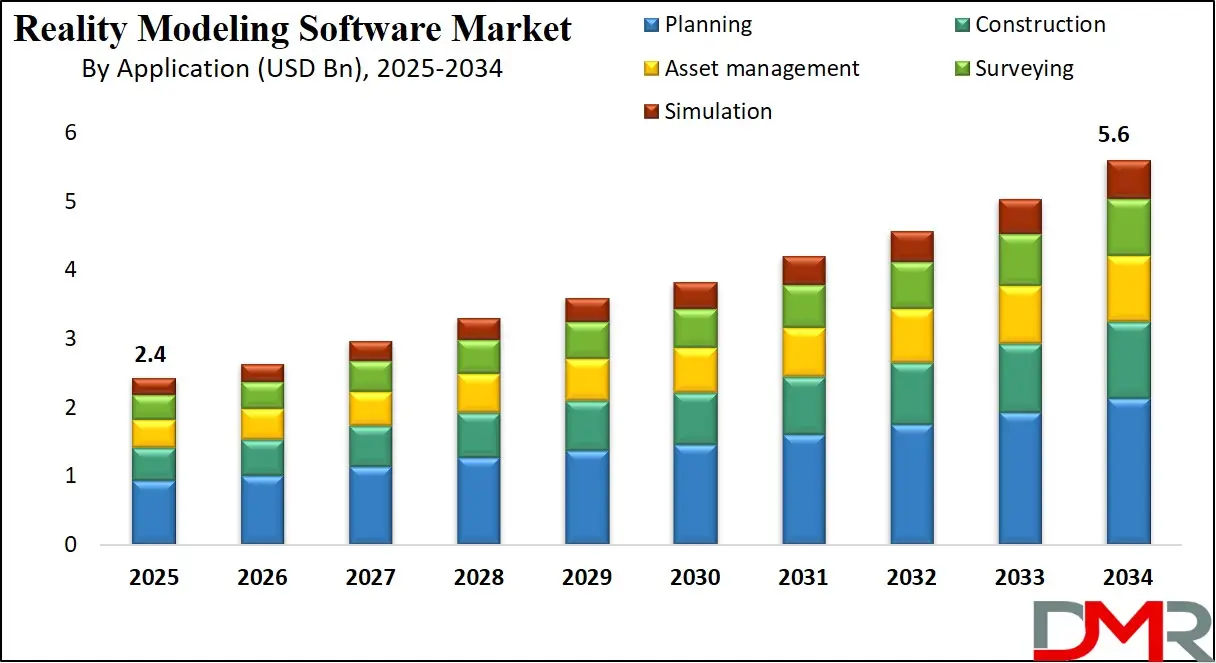
The global reality modeling software market is projected to be valued at approximately USD 2.4 billion in 2025 and is expected to reach USD 5.6 billion by 2034, expanding at a CAGR of 9.8%, driven by rising adoption of reality capture technologies 3-D modeling digital twin platforms spatial analytics and cloud based visualization solutions across construction infrastructure urban planning and geospatial applications.
Reality modeling software refers to specialized digital solutions designed to capture process and convert real world physical environments into accurate 3-D digital representations. These platforms integrate technologies such as photogrammetry laser scanning point cloud processing and spatial analytics to generate high fidelity models of buildings terrain infrastructure and assets.

Reality modeling software enables users to visualize measure analyze and simulate real world conditions within a virtual environment supporting data driven decision making across planning design construction and operational workflows. The software acts as a bridge between physical and digital spaces by transforming raw spatial data into usable models that reflect real world geometry scale and context.
The global reality modeling software market represents the worldwide ecosystem of vendors technologies and solutions delivering digital reality capture and modeling capabilities across industries. This market is driven by the growing adoption of digital transformation initiatives where organizations increasingly rely on 3-D visualization and spatial intelligence to improve accuracy efficiency and collaboration. Widespread use in architecture engineering construction infrastructure development surveying and urban planning has positioned reality modeling software as a foundational component of modern project lifecycles enabling improved planning reduced rework and enhanced asset visibility.
At a global level the market is shaped by advancements in cloud computing artificial intelligence and geospatial technologies which are expanding the scalability and analytical depth of reality modeling platforms. Increasing demand for digital twins smart city development remote project monitoring and lifecycle asset management continues to fuel adoption across both developed and emerging economies. As organizations seek more precise real time and immersive insights into physical environments the global reality modeling software market continues to evolve as a critical enabler of spatial data driven operations and long term infrastructure intelligence.
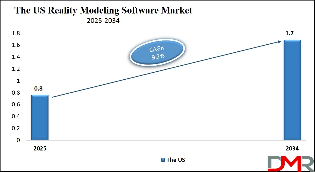
The US Reality Modeling Software Market
The U.S. Reality Modeling Software market size is projected to be valued at USD 0.8 billion by 2025. It is further expected to witness subsequent growth in the upcoming period, holding USD 1.7 billion in 2034 at a CAGR of 9.2%.
The United States reality modeling software market represents the most mature and technologically advanced segment globally, driven by strong adoption across architecture engineering and construction infrastructure development and geospatial analysis applications. Widespread integration of reality capture technologies photogrammetry point cloud processing and 3-D reconstruction tools has enabled organizations to enhance planning accuracy reduce project risks and improve collaboration across complex workflows.
Federal and state level investments in transportation networks smart infrastructure and urban development along with high penetration of building information modeling and digital twin initiatives continue to accelerate demand for advanced reality modeling platforms across both public and private sectors.
Market growth in the US is further supported by rapid advancements in cloud computing artificial intelligence and spatial data analytics which enhance scalability real time visualization and predictive modeling capabilities. Increasing use of unmanned aerial vehicles laser scanning and mobile mapping systems has significantly expanded the volume of spatial data requiring sophisticated processing and visualization software.
Additionally growing emphasis on lifecycle asset management remote monitoring and sustainability driven construction practices is strengthening the role of reality modeling software in operational decision making. As enterprises prioritize data driven design automation and immersive visualization the US reality modeling software market continues to evolve as a core component of the country’s digital construction and infrastructure ecosystem.
Europe Reality Modeling Software Market
The European reality modeling software market is projected to reach approximately USD 600 million in 2025, reflecting strong adoption across architecture, engineering, construction, and infrastructure sectors. The growth is fueled by increasing investments in digital twin technologies, building information modeling integration, and cloud-based spatial analytics solutions that enhance planning accuracy, streamline project execution, and improve asset management.
Enterprises across Western and Northern Europe are leveraging reality capture tools, photogrammetry platforms, and three-dimensional reconstruction software to optimize workflows, reduce rework, and improve collaboration among project stakeholders.
The market is further supported by government initiatives promoting smart city development, transportation modernization, and urban infrastructure projects, which require precise 3D modeling and geospatial visualization. Increasing integration of AI-driven analytics, point cloud processing, and immersive visualization technologies is enhancing the efficiency of reality modeling platforms, enabling real-time decision-making and predictive maintenance. With a compound annual growth rate of 9.2%, Europe continues to be a significant regional contributor, driven by technological adoption, regulatory support, and the presence of established vendors in the reality modeling software ecosystem.
Japan Reality Modeling Software Market
The Japanese reality modeling software market is projected to reach approximately USD 200 million in 2025, driven by rapid adoption of advanced technologies in construction, infrastructure, and urban planning projects. Increasing investments in smart city initiatives, transportation networks, and industrial facilities are fueling demand for reality capture, photogrammetry, and three-dimensional reconstruction software. Enterprises in Japan are leveraging these solutions to improve design accuracy, monitor project progress, and integrate digital twin and building information modeling platforms for more efficient asset management and operational workflows.
The market is further supported by the integration of AI-powered analytics, cloud-based visualization, and point cloud processing technologies, which enhance modeling precision, real-time decision-making, and predictive maintenance capabilities. High demand for immersive visualization, spatial data analytics, and automated modeling solutions is accelerating adoption across both public and private sectors. With a compound annual growth rate of 10.5%, Japan represents a high-growth regional market in the reality modeling software industry, driven by technological innovation, infrastructure modernization, and the need for efficient, data-driven project execution.
Global Reality Modeling Software Market: Key Takeaways
- Market Growth and Forecast: The global reality modeling software market is projected to grow from USD 2.4 billion in 2025 to USD 5.6 billion by 2034 at a CAGR of 9.8%. This growth is fueled by the rising adoption of 3D modeling, digital twin platforms, spatial analytics, and cloud-based visualization solutions across construction, infrastructure, and urban planning projects.
- Regional Insights: North America is expected to lead the market with a 38% revenue share in 2025, supported by advanced technology adoption and government initiatives. Meanwhile, Asia Pacific, particularly Japan, is emerging as a high-growth region driven by smart city projects, infrastructure modernization, and digital twin integration.
- Component and Deployment Trends: Software dominates the market component segment with 70% share, reflecting widespread use of reality capture and visualization tools. Cloud deployment captures 60% of the deployment mode segment, emphasizing the importance of scalable, collaborative, and remote-access solutions in modern workflows.
- Enterprise Adoption: Large enterprises represent 52% of the market, driven by their ability to invest in advanced reality capture technologies, AI analytics, and point cloud processing. These organizations use reality modeling software to optimize planning, reduce errors, and manage assets across construction, infrastructure, and urban projects.
- Emerging Trends and Technology Drivers: Key trends include integration of AI for automated point cloud processing, cloud-based collaborative platforms for real-time project management, and extensive use of drones and mobile scanning devices. These technologies enhance modeling accuracy, operational efficiency, and enable data-driven decision-making across industries.
Global Reality Modeling Software Market: Use Cases
- Construction Planning and Design Optimization: Reality modeling software is widely used in construction planning to create accurate 3-D site models from reality capture and point cloud data. These models support design validation clash detection and integration with building information modeling workflows. By enabling precise visualization of existing conditions the software helps reduce design errors minimize rework and improve coordination among architects engineers and contractors across complex construction projects.
- Infrastructure Development and Smart Cities: In large scale infrastructure and smart city projects reality modeling software supports urban planning transportation design and public asset visualization. Governments and planners use spatial analytics digital terrain models and 3-D city models to evaluate land use traffic flow and infrastructure placement. The software enhances decision making by providing realistic simulations and geospatial insights for roads railways utilities and public facilities.
- Asset Management and Digital Twin Operations: Reality modeling software plays a critical role in asset management by enabling the creation of digital twins for buildings plants and infrastructure assets. These virtual representations support inspection maintenance planning and lifecycle management using real world spatial data. Integration with cloud platforms and analytics tools allows organizations to monitor asset conditions remotely improve operational efficiency and extend asset lifespan.
- Surveying Mapping and Geospatial Analysis: Surveyors and geospatial professionals use reality modeling software for topographic mapping land surveying and terrain analysis. Photogrammetry and laser scanning technologies are processed into accurate spatial models for boundary assessment volume calculations and environmental analysis. This use case is essential for mining infrastructure development and land management projects requiring high accuracy and spatial intelligence.
Impact of Artificial Intelligence on the global Reality Modeling Software market
The integration of artificial intelligence in the global reality modeling software market has significantly enhanced automation accuracy and predictive capabilities across spatial data workflows. AI-driven algorithms improve point cloud classification photogrammetry processing and three-dimensional reconstruction by reducing manual intervention and increasing modeling precision.
Machine learning components enable rapid extraction of features from raw scans and images, accelerate reality capture workflows and enhance semantic segmentation for more intelligent asset recognition. As a result organizations can generate high fidelity digital twins faster with fewer errors, improving design validation and construction planning efficiency.
AI also boosts analytical depth and decision support within reality modeling platforms by enabling predictive analytics anomaly detection and automated quality assessment of spatial datasets. Natural language processing and pattern recognition improve user interaction and data querying, while deep learning enhances object detection within complex environments.
With cloud-based AI models scaling computational performance, enterprises can perform real time visualization simulation and scenario planning at larger geographies and with greater detail. Overall artificial intelligence strengthens the value proposition of reality modeling software by optimizing data processing workflows, enhancing model intelligence and enabling proactive insights across construction, infrastructure, surveying and asset management use cases.
Global Reality Modeling Software Market: Stats & Facts
- United States — Federal Geospatial and 3D Data Programs
- At the end of fiscal year 2023, 94.7% of the United States had elevation data meeting 3D Elevation Program (3DEP) specifications for high‑accuracy topographic and point cloud data, supporting infrastructure planning, flood risk mapping, and geospatial decision making.
- The 3DEP program continues nationwide data acquisition to provide a consistent high‑resolution three‑dimensional dataset for public use.
- GAO report (FY 2022–2023) shows that of 23 federal civilian agencies surveyed, 17 reported activities involving immersive technologies.
- 16 federal agencies plan to adopt or expand immersive technology initiatives from FY 2024–2028.
- 13 agencies reported plans to conduct or fund research and development related to immersive technologies in FY 2024–2028.
- Australia (NSW Government) — Spatial Digital Twin Initiatives
- The NSW Spatial Digital Twin includes comprehensive 3D datasets incorporating 22 million trees with height and canopy attributes, approximately 20,000 km of 3D roads, 7,000 3D strata plans, and 546,206 buildings mapped for Western Sydney.
- The platform extends 3D and 4D visualization capabilities to regional cities like Bathurst, enabling local councils and planners to interact with detailed spatial datasets and infrastructure models for decision making and community engagement.
- European Union — Destination Earth (DestinE) Digital Twin Project
- Launched under the Digital Europe programme, Destination Earth is a multi‑component digital twin of the Earth system used to simulate climate, weather extremes, and human activities for policy and environmental planning.
- Core system components and operational implementations were achieved by 2024, supporting environmental monitoring, urban planning, and climate resilience modeling.
- Singapore — Virtual Singapore 3D Digital Twin Project
- The Government of Singapore completed a national 3D digital twin platform integrating over 50 terabytes of geospatial data collected via aerial and land surveys.
- The platform enables detailed urban planning, simulation, and smart nation applications, representing one of the first country‑scale digital twin initiatives globally.
Global Reality Modeling Software Market: Market Dynamics
Global Reality Modeling Software Market: Driving Factors
Rising Adoption of Digital Twin and BIM Technologies
The increasing integration of digital twin solutions and building information modeling (BIM) in construction, infrastructure, and urban planning projects is driving demand for reality modeling software. Organizations are leveraging these platforms to enhance design visualization, streamline planning workflows, and improve operational efficiency. The ability to create accurate three-dimensional models and simulate real-world conditions ensures reduced rework, improved asset management, and faster project delivery, which significantly boosts market growth.
Growth of Reality Capture and Spatial Data Analytics
The proliferation of advanced reality capture technologies, including photogrammetry, LiDAR scanning, and drone-based imaging, has created a surge in spatial data generation. Reality modeling software enables efficient processing, visualization, and analysis of this data, allowing enterprises to extract actionable insights for surveying, construction monitoring, and infrastructure management. The combination of high-resolution data capture with sophisticated analytics accelerates adoption across engineering, mining, and urban development sectors.
Global Reality Modeling Software Market: Restraints
High Implementation Costs
The deployment of reality modeling software often requires substantial investments in hardware, software licenses, and skilled personnel capable of operating photogrammetry, point cloud processing, and 3D reconstruction tools. These high upfront costs can deter small and medium-sized enterprises from adopting the technology, limiting market penetration in certain regions and industries.
Data Complexity and Processing Challenges
The massive volumes of spatial and point cloud data generated during reality capture processes can be difficult to process, store, and manage effectively. Without sufficient computational infrastructure and optimized algorithms, data handling can become a bottleneck, leading to longer processing times and potential inaccuracies in model generation, which restrains widespread adoption.
Global Reality Modeling Software Market: Opportunities
Expansion in Smart City and Infrastructure Projects
The global focus on smart city initiatives, intelligent transportation systems, and urban infrastructure development provides significant opportunities for reality modeling software. Accurate 3D models of urban environments and infrastructure assets facilitate better planning, monitoring, and simulation, enabling governments and private developers to optimize construction workflows and enhance operational efficiency.
Integration with Artificial Intelligence and Machine Learning
Advancements in AI and machine learning present opportunities to automate point cloud classification, object detection, and semantic segmentation within reality modeling platforms. These enhancements can reduce manual intervention, improve predictive maintenance, and enable real-time simulation, creating new use cases across construction, surveying, and asset management while increasing software adoption in both mature and emerging markets.
Global Reality Modeling Software Market: Trends
Cloud-Based and Collaborative Platforms
|There is a growing trend toward cloud-based reality modeling software that allows real-time collaboration, remote access, and scalable processing of large spatial datasets. Cloud deployment enhances project coordination across multiple teams and geographies, supports high-resolution 3D visualization, and facilitates integration with digital twin and BIM platforms.
Increasing Use of Drones and Mobile Scanning Devices
The adoption of drones, UAVs, and handheld 3D scanners is transforming data acquisition for reality modeling software. These devices provide rapid, high-accuracy spatial data capture in construction sites, mining operations, and infrastructure projects, reducing survey time, improving precision, and enabling frequent updates to digital models.
Global Reality Modeling Software Market: Research Scope and Analysis
By Component Analysis
In the reality modeling software market, software components are expected to dominate the component segment, capturing 70% of the total market share in 2025. This dominance is driven by the widespread adoption of advanced reality capture tools, 3-D reconstruction software, photogrammetry platforms, and visualization solutions that enable accurate design, efficient project planning, and streamlined construction workflows. Software forms the backbone of reality modeling solutions by processing large volumes of spatial data, integrating with digital twin and building information modeling platforms, and facilitating real time simulation and immersive visualization.
Services form the remaining part of the component segment and include consulting, implementation, training, technical support, and managed services. These offerings help organizations deploy software effectively, optimize workflows, ensure high quality model generation, and maintain system updates. The service segment plays a crucial role in enabling enterprises to fully utilize reality modeling software for enhanced project efficiency, improved asset management, and reduced operational risks across construction, infrastructure, and urban planning applications.
By Deployment Mode Analysis
In the reality modeling software market, cloud deployment is expected to dominate the deployment mode segment, capturing 60% of the total market share in 2025. This growth is driven by the increasing need for scalable computing resources, remote access to high resolution spatial data, and real time collaboration among geographically dispersed teams.
Cloud based solutions enable enterprises to process large volumes of point cloud and photogrammetry data efficiently, integrate seamlessly with digital twin and building information modeling platforms, and support immersive visualization and simulation without the limitations of local hardware. The flexibility, lower upfront investment, and ability to update software continuously make cloud deployment the preferred choice for many organizations across construction, infrastructure, and urban planning projects.
On premises deployment accounts for the remaining part of the segment and is adopted by organizations that require strict data security, compliance with regulatory standards, and full control over infrastructure. This mode allows enterprises to manage sensitive spatial data internally, customize software configurations, and maintain consistent performance without relying on internet connectivity. On premises solutions are particularly relevant for large enterprises, government agencies, and industries with stringent privacy and operational requirements, providing stability and control while still supporting advanced modeling, visualization, and analytics workflows.
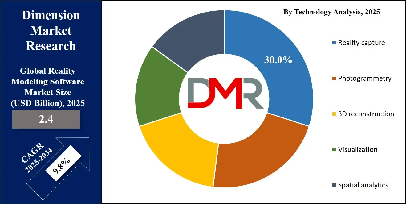
By Technology Analysis
In the reality modeling software market, reality capture technology is expected to dominate the technology segment, capturing 30% of the total market share in 2025. This segment includes solutions that acquire accurate spatial data from the physical environment using tools such as LiDAR scanners, drones, and terrestrial laser scanning. Reality capture enables the creation of precise point clouds and 3-D datasets that form the foundation for modeling, visualization, and analysis. The widespread adoption of reality capture technology is driven by its ability to reduce manual survey efforts, improve design accuracy, and facilitate faster project execution across construction, infrastructure, and urban planning applications.
Photogrammetry represents another significant part of the technology segment and focuses on converting two dimensional images into detailed 3-D models. This technology allows organizations to generate high resolution digital representations of terrain, buildings, and infrastructure by analyzing overlapping images captured from drones, cameras, or satellites.
Photogrammetry enhances project planning, site monitoring, and asset management by providing accurate measurements and geospatial insights. Its adoption is growing due to cost efficiency, ease of integration with other reality modeling software tools, and applicability in surveying, construction monitoring, and digital twin creation.
By Organization Size Analysis
In the reality modeling software market, large enterprises are expected to dominate the organization size segment, capturing 52% of the total market share in 2025. This dominance is driven by their substantial investments in advanced technologies, including reality capture, photogrammetry, and 3-D reconstruction software.
Large organizations often operate complex construction, infrastructure, and urban planning projects that require high precision, scalability, and integration with digital twin and building information modeling platforms. Their capacity to invest in cloud deployment, high performance computing, and skilled personnel allows them to leverage reality modeling software to enhance project efficiency, reduce errors, and improve asset management across multiple sites.
Small and medium sized enterprises represent the remaining part of the organization size segment and adopt reality modeling software primarily for specialized projects or niche applications. SMEs benefit from cloud based solutions and subscription models that reduce upfront costs and allow access to advanced spatial analytics and visualization tools. While their scale of operations is smaller, SMEs increasingly use these platforms for surveying, construction monitoring, and digital twin integration to improve project accuracy, enhance collaboration, and maintain competitiveness in the market.
By Application Analysis
In the reality modeling software market, planning is expected to dominate the application segment, capturing 38% of the total market share in 2025. This dominance is driven by the increasing reliance on digital tools for project design, urban development, and infrastructure planning.
Reality modeling software enables precise site analysis, 3-D modeling, and integration with building information modeling and digital twin platforms, allowing stakeholders to simulate scenarios, assess risks, and optimize layouts before actual construction begins. The use of these tools in planning reduces design errors, minimizes rework, and enhances coordination among architects, engineers, and project managers, improving overall project efficiency.
Construction represents another important part of the application segment and focuses on using reality modeling software to monitor project progress, track materials, and ensure quality compliance. By capturing real time spatial data and integrating it with planning models, construction teams can compare as built conditions with design specifications, detect deviations early, and optimize workflows. This application helps improve accuracy, reduce delays, and enhance safety on construction sites, making reality modeling software a vital tool for executing complex infrastructure and building projects efficiently.
By End-User Analysis
In the reality modeling software market, construction and infrastructure is expected to dominate the end-user industry segment, capturing 60% of the total market share in 2025. This dominance is driven by the extensive adoption of reality capture, 3-D reconstruction, and visualization technologies in large-scale building projects, transportation networks, and civil infrastructure development.
These solutions allow project managers, engineers, and architects to create accurate digital models, simulate scenarios, and monitor progress in real time, improving planning accuracy and reducing rework. The integration of digital twin and building information modeling platforms further enhances coordination, optimizes resource allocation, and ensures timely project delivery across complex infrastructure projects.
Public sectors represent another significant part of the end-user segment and leverage reality modeling software for urban planning, smart city initiatives, and government infrastructure projects. These organizations use spatial analytics, photogrammetry, and point cloud processing to manage city assets, monitor construction progress, and plan public utilities efficiently. The software enables data-driven decision making, enhances transparency, and supports regulatory compliance, helping government agencies improve project outcomes while ensuring sustainable and efficient use of resources.
The Reality Modeling Software Market Report is segmented on the basis of the following:
By Component
By Deployment Mode
By Technology
- Reality capture
- Photogrammetry
- 3D reconstruction
- Visualization
- Spatial Analytics
By Organization Size
By Application
- Planning
- Construction
- Asset management
- Surveying
- Simulation
By End-User
- Construction & Infrastructure
- Public Sectors
- Manufacturing
- Others
Global Reality Modeling Software Market: Regional Analysis
Region with the Largest Revenue Share
North America is expected to lead the global reality modeling software market, accounting for 38% of the total market revenue in 2025. The region’s dominance is driven by high adoption of advanced technologies such as reality capture, photogrammetry, 3-D reconstruction, and digital twin platforms across construction, infrastructure, and urban planning projects.
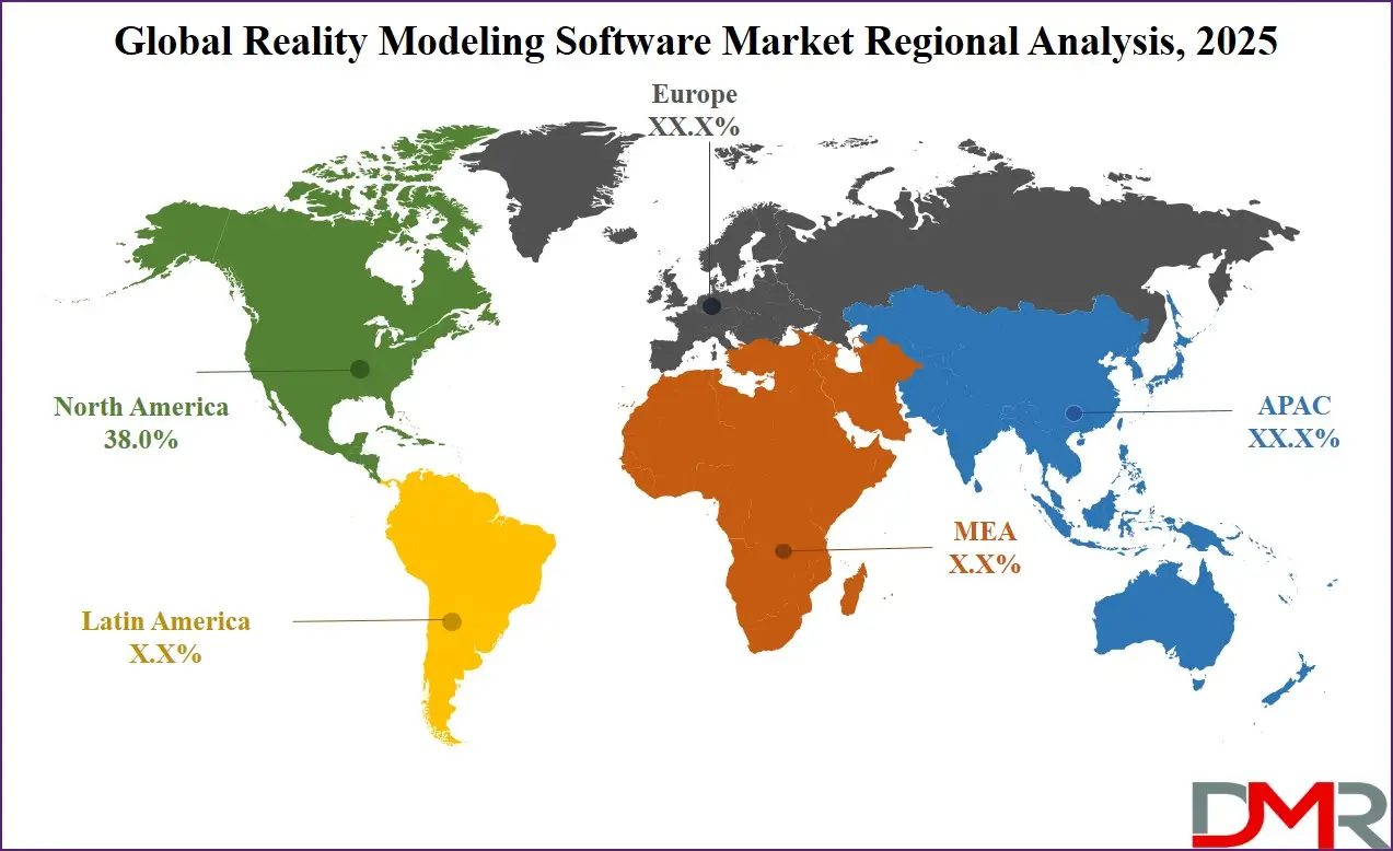
Strong investments in smart city initiatives, building information modeling integration, and cloud-based spatial analytics solutions further support market growth. Additionally, the presence of major software vendors, favorable government regulations, and the widespread use of drones and LiDAR scanning for surveying and asset management contribute to North America’s leading position in the global reality modeling software market.
Region with significant growth
The Asia Pacific region is expected to witness significant growth in the reality modeling software market over the coming years. Rapid urbanization, large-scale infrastructure development, and increasing adoption of smart city initiatives are driving demand for advanced reality capture, photogrammetry, and 3-D modeling solutions.
Growing investments in construction, transportation, and energy sectors, coupled with rising awareness of digital twin and building information modeling technologies, are accelerating market expansion. Additionally, the increasing availability of cloud-based platforms and scalable spatial analytics tools enables enterprises and government agencies in the region to implement efficient planning, asset management, and project monitoring, positioning Asia Pacific as a high-growth market globally.
By Region
North America
Europe
- Germany
- The U.K.
- France
- Italy
- Russia
- Spain
- Benelux
- Nordic
- Rest of Europe
Asia-Pacific
- China
- Japan
- South Korea
- India
- ANZ
- ASEAN
- Rest of Asia-Pacific
Latin America
- Brazil
- Mexico
- Argentina
- Colombia
- Rest of Latin America
Middle East & Africa
- Saudi Arabia
- UAE
- South Africa
- Israel
- Egypt
- Rest of MEA
Global Reality Modeling Software Market: Competitive Landscape
The global reality modeling software market is highly competitive, characterized by continuous technological innovation, strategic partnerships, and product enhancements. Vendors are focusing on developing advanced reality capture, photogrammetry, and 3-D reconstruction solutions with improved accuracy, faster processing, and cloud-based deployment capabilities.
Companies are also emphasizing integration with digital twin platforms, building information modeling, and spatial analytics tools to provide end-to-end modeling and visualization workflows. The competitive landscape is further shaped by investments in research and development, expansion into emerging markets, and the introduction of subscription-based and scalable software models, enabling organizations across construction, infrastructure, and urban planning sectors to adopt advanced reality modeling solutions efficiently.
Some of the prominent players in the global Reality Modeling Software market are
- Autodesk Inc.
- Bentley Systems Incorporated
- Trimble Inc.
- Hexagon AB
- Esri Inc.
- Pix4D SA
- Agisoft LLC
- Capturing Reality
- Matterport Inc.
- Topcon Corporation
- FARO Technologies
- Leica Geosystems
- NavVis
- GeoSLAM
- RIEGL Laser Measurement Systems
- DroneDeploy Inc.
- Paracosm Inc.
- 3Dflow SRL
- PhotoModeler Technologies
- Skyline Software Systems
- Other Key Players
Global Reality Modeling Software Market: Recent Developments
- January 2025: Trimble launched a new cloud‑based reality capture platform service that streamlines the management, visualization, and collaboration of large spatial datasets captured from 3D laser scanning, mobile mapping, and unmanned aerial vehicles by integrating with its Connect ecosystem to support point cloud workflows across construction, surveying, and infrastructure projects.
- January 2025: An immersive technology company raised USD 3 billion in additional funding, significantly boosting its valuation and enabling accelerated development of no‑code immersive experiences, digital twin solutions, and advanced spatial computing products for global markets.
- September 2024: A leading unified reality intelligence platform for construction secured USD 4.3 million in seed funding to expand its AI‑powered reality capture and progress monitoring tools, enhancing automated data insights and decision support for project teams.
Report Details
| Report Characteristics |
| Market Size (2025) |
USD 2.4 Bn |
| Forecast Value (2034) |
USD 5.6 Bn |
| CAGR (2025–2034) |
9.8% |
| The US Market Size (2025) |
USD 0.8 Bn |
| Historical Data |
2019 – 2024 |
| Forecast Data |
2026 – 2034 |
| Base Year |
2024 |
| Estimate Year |
2025 |
| Report Coverage |
Market Revenue Estimation, Market Dynamics, Competitive Landscape, Growth Factors and etc. |
| Segments Covered |
By Component (Software, Services), Deployment Mode (Cloud, On-premises, Hybrid), Technology (Reality Capture, Photogrammetry, 3D Reconstruction, Visualization, Spatial Analytics), Organization Size (Large Organizations, SMEs), Application (Planning, Construction, Asset Management, Surveying, Simulation), and End-User (Construction & Infrastructure, Public Sectors, Manufacturing, Others). |
| Regional Coverage |
North America – The US and Canada; Europe – Germany, The UK, France, Russia, Spain, Italy, Benelux, Nordic, & Rest of Europe; Asia-Pacific – China, Japan, South Korea, India, ANZ, ASEAN, Rest of APAC; Latin America – Brazil, Mexico, Argentina, Colombia, Rest of Latin America; Middle East & Africa – Saudi Arabia, UAE, South Africa, Turkey, Egypt, Israel, & Rest of MEA |
| Prominent Players |
Autodesk Inc., Bentley Systems Incorporated, Trimble Inc., Hexagon AB, Esri Inc., Pix4D SA, Agisoft LLC, Capturing Reality, Matterport Inc., Topcon Corporation, FARO Technologies, Leica Geosystems, NavVis, GeoSLAM, RIEGL Laser Measurement Systems, DroneDeploy Inc., and Others. |
| Purchase Options |
We have three licenses to opt for: Single User License (Limited to 1 user), Multi-User License (Up to 5 Users), and Corporate Use License (Unlimited User) along with free report customization equivalent to 0 analyst working days, 3 analysts working days, and 5 analysts working days respectively. |
Frequently Asked Questions
The global Reality Modeling Software market size is estimated to have a value of USD 2.4 billion in 2025 and is expected to reach USD 5.6 billion by the end of 2034.
The US Reality Modeling Software market is projected to be valued at USD 0.8 billion in 2025. It is expected to witness subsequent growth in the upcoming period as it holds USD 1.7 billion in 2034 at a CAGR of 9.2%.
North America is expected to have the largest market share in the global Reality Modeling Software market, with a share of about 38.0% in 2025.
Some of the major key players in the global Reality Modeling Software market are Autodesk Inc., Bentley Systems Incorporated, Trimble Inc., Hexagon AB, Esri Inc., Pix4D SA, Agisoft LLC, Capturing Reality, Matterport Inc., Topcon Corporation, FARO Technologies, Leica Geosystems, NavVis, GeoSLAM, RIEGL Laser Measurement Systems, DroneDeploy Inc., and Others.